 Coal that was once peat accumulating in near-shore swamps also occurs.
 Neighbours, I am told that some of you might like to read the following short account of the geology of Piers Island. Soon perhaps I shall expand this version by mentioning where good examples of the rock types, etc. mentioned in this account can be seen.
Piers Island has a base of very old solid rock covered in places by a veneer of much younger deposits laid down during and after the last ice age. The solid rock is best seen in the almost continuous series of outcrops along the shore and also crops out conspicuously on the cliffs and around the summit in the western part of the island. It is the cause of the aggravating bump in the road opposite lot 110 and in the form of submerged rocks has bent many a propeller.
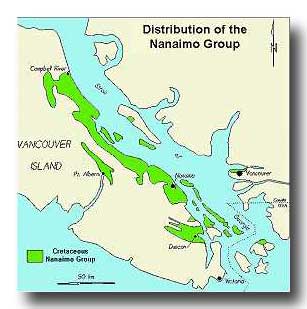
Rocks are sedimentary, igneous or metamorphic. Piers Island bedrock is sedimentary and belongs to a sequence of strata known to geologists as the Nanaimo Group that was deposited during the latter part of the Cretaceous Period, 85 to 65 million years ago. Over 4,000 m thick, these rocks occur today largely in the Gulf Islands and SE Vancouver Island. They originated mainly as muds, silts, sands and gravels that are now mudstones, siltstones, sandstones and conglomerates, respectively. Coal that was once peat accumulating in near-shore swamps also occurs.
Whereas some sediments were deposited in shallow water, others have a deeper water origin. The shallow water sediments were carried westwards to their final destinations from the mouths of rivers by wave action and tidal currents. The gravels and sands came to rest in quite shallow water whereas the silts and muds travelled farther. Such sediments, especially the finer grained ones, when shaken by earthquakes tended to form sediment-rich liquids that moved under gravity into deeper water. In general a layer settling out from a single gravity flow is only a few centimetres thick. Such layers can commonly be recognized by the gradual decrease in grain size from bottom to top, the coarse grained, generally silty base of one layer resting sharply on the fine grained, generally muddy top of the one below. The siltstones and mudstones are dark coloured and the alternation of grain size gives them a banded appearance; they are well displayed along the shore on all sides of the island. Some shallow-water sediments moved only short distances down slope and, although still intact, have a contorted appearance. The sandstone layers are thicker and consist of visible grains of quartz, feldspar and rock fragments; they are resistant to erosion and occur on the cliffs and near the summit on the west side of the island. The conglomerates are also resistant to erosion and are easy to recognize; they occur mainly along the shore on the southeast side of the island. The northern part of the Saanich peninsula is also underlain by Nanaimo Group strata but the southern part of Salt Spring Island including Mount Tuam is made of older rocks.
Marine sedimentary rocks commonly contain fossils that are the hard parts of animals living in the sea at the time of deposition. Most fossils in the Nanaimo Group are the remains of bottom living shellfish such as clams and snails. This seems to be the case on our island although some beds contain plants. The plant-bearing strata may have been deposited near or on the deltas of rivers. Farther north, near Courtenay, the remains of ammonites (extinct relatives of the modern cephalopod Nautilus), fish, turtles and other swimming reptiles called plesiosaurs have been found. The best preserved fossils commonly occur in rounded lumps called concretions. Fossils on Piers Island are plentiful in a very hard and greenish-grey rock that has been exposed on the point in front of lot 75 and runs west across the island, reappearing on the opposite side.
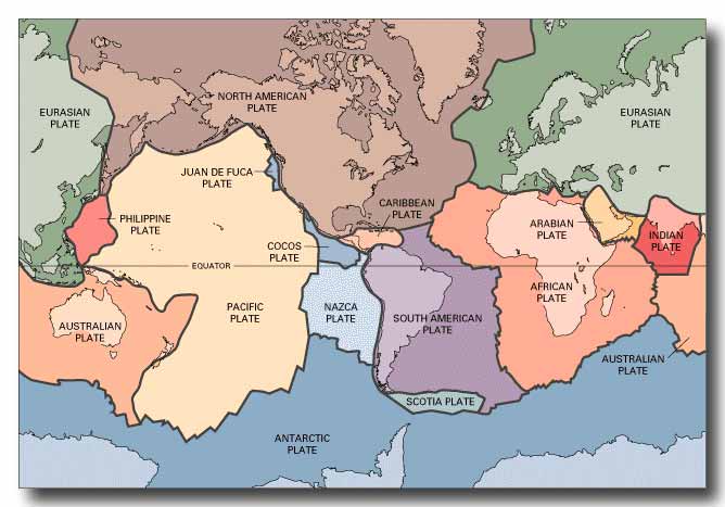
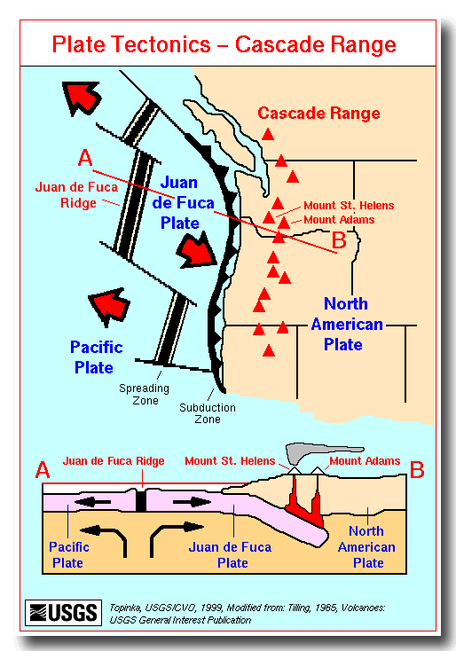
The Earth has a central iron core and a silicate mantle that although crystalline behaves in the long term like a viscous fluid, in other words a bit like silly putty. The Earth’s strong outer rind or lithosphere, 15-200 km thick, consists of more or less rigid plates that move with respect to each other over the fluid mantle. Convection caused by radioactive heat drives these movements. Today the small Juan de Fuca plate west of Vancouver Island and the large North American plate are moving towards one another at 3 cm/year. Movement along the boundary between these plates is responsible for most of the earthquakes felt on Piers Island, and partial melting of the Juan de Fuca plate as it descends beneath North America is the source of lava for the Mount Baker and related volcanoes. The boundary between these plates occurs out to sea 150 km to the southwest, and beneath us is at a depth of 50 km. The last major earthquake (magnitude 9) to have been caused by movement along this plate boundary is thought to have occurred during the evening of 26 March 1700. There are three kinds of earthquake wave. The P and S waves are the fastest and have a low amplitude. The L waves make up for being the slowest by having the largest amplitude and causing the greatest damage. In July when a house guest announced at the breakfast table that at about 1 a.m. articles on her glass-topped dressing table rattled for a few seconds, then after a few seconds rattled again, and finally a few seconds later she felt the bed shake, I was able to tell her that she had just experienced an earthquake.
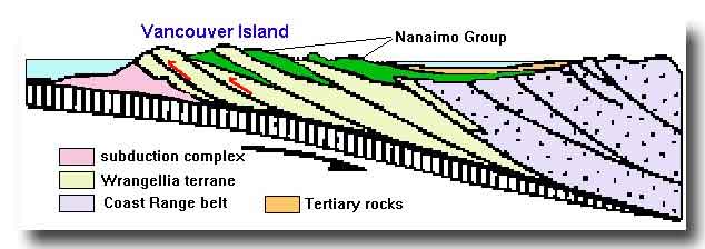
Much of British Columbia consists of remnants of other plates that collided with North America at various times during the past few hundred million years. The older rocks of Vancouver Island and the Gulf Islands belonged to a plate (Wrangellia) that collided in early Cretaceous time. Nanaimo Group sediments began to be deposited on Wrangellia shortly after this collision. During their deposition and for some time afterwards, Wrangellia moved NW past the North American plate just as today western California, Baja California and the Pacific plate to which they belong is moving NW past the rest of the country along the San Andreas fault. Thus Nanaimo Group sediments were derived not by erosion of the Coast and Cascade Mountains but from areas that today are up to 1500 km to the SE.
Shortly after the end of the Cretaceous period renewed inward movement of Wrangellia against the North American plate subjected Nanaimo group strata, particularly those in what are now the Gulf Islands, to compression and to faulting and folding. Thus on Piers Island these strata, although once nearly horizontal, now dip at angles of up to 90º. Some small folds can be seen if you look east at the front of lot 5 from the walkway of the Government dock. The rock has been so contorted that it almost looks like the roots of the trees above.
Ice originating as valley glaciers in the Coast Mountains arrived here some 25,000 years ago. The glaciers coalesced to form an ice sheet that moved S to cover much of Vancouver Island. The topography of the land surface and sea floor today is the result of pre-glacial and glacial erosion. Piers Island exists as a topographic high mainly because its rocks resisted erosion better than the surrounding areas. The ice sheet carried with it boulders and other debris eroded from the Coast Mountains formed mainly of plutonic and metamorphic rocks. These materials were carried southwards and settled out from the ice sheet near its edges. This is the origin of the boulders of coarse-grained crystalline rocks that occur throughout the island and differ so conspicuously from the sedimentary bedrock. The largest boulders are in the orchard.
The region became free of ice about 12,000 years ago. At this time, owing to the lithosphere having been depressed by the weight of ice, all or most of Piers Island was submerged. Sea level reached a maximum of 75 m above present levels near Victoria and 150 m near Courtenay. The thin clay that overlies bedrock in parts of the Piers Island was deposited at this time. The land then rose until about 10,000 years ago, by which time Piers Island and the Saanich peninsula had fully emerged. Beaches formed during this interval and now above sea level are to be found in the Gulf Islands in many places. The existence of narrow inlets such as Gorge Creek in Victoria suggests that in recent times sea level has fallen slightly.
I would like to acknowledge Dr. P.S. Mustard for diagrams 1, 2, and 4 and the U.S. Geological Survey for diagram 3 and my son-in-law, Mark, for constructing this site.
Henry Charlesworth
Piers Island, 27 March 2005